
The Overseas Highway is a section of US1 that traverses the Florida Keys. Much of it was built on the right-of-way of the Overseas Railroad, an extension of the Florida East Coast Railway. The Overseas Highway originally used many of the former railroad bridges, but most have been replaced with more modern versions. Remnants of some of the older bridges still exist and are used for pedestrian visits and fishing.
Historic Bridges
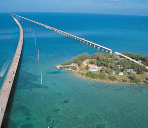
Seven Mile Bridge. Two bridges exist in one location, although one of them no longer connects to the Intracoastal Waterway. The old bridge had a swing span that could be moved to allow for boat traffic. The span has been removed, but the rest of the bridge still exists and can be used to reach the island of Pigeon Key. The guardrails on the bridge were created from railroad track that was dismantled and repainted.
Bahia Honda Rail Bridge. Two sections of the bridge have been removed to allow easy passage for boats and discourage pedestrians from using the collapsing structure. The portion adjacent to Bahia Honda State Park is maintained as an overlook for park visitors.
Long Key Bridge. The pedestrian only bridge is strictly for fishing and enjoyment now. For some reason the area seems to attract large sharks and anglers keep a record of who can catch the largest hammerhead.
The Modern Highway
From Key West to Key Largo, locations are frequently referred to by their mile marker location. The first three or four digits indicate the approximate mile marker location of the business or structure, and the last two digits are the address. Even digits mean the address is on the Atlantic side of the highway, and odd digits are for a Florida Bay/Gulf of Mexico address. Note that Key West is Mile Marker 0 (MM0), so the numbers decrease as you progress south from Key Largo. Knowing this will help keep you oriented when driving through the Keys.
The whole of the modern Overseas Highway is a structural wonder. The 42 overseas bridges arc from island to island along the full 113 miles of the highway. It is possible to travel to MM0 on Key West from Miami in less than four hours, but the diversity of the islands and the natural beauty of the area often entices people take the journey much more slowly.
The Bridges
Your journey really starts at the Florida Everglades although the stretch of road between the everglades and Key Largo is a bit dull. The group of islands nearest to the mainland is known as the Upper Keys.
MM107.2 is the Jewfish Creek drawbridge and the entrance to Key Largo.
At MM 103.4, the Marvin Adams Waterway Bridge crosses a man made canal that divides Key Largo.
If the Caribbean Club at MM 104.1 looks familiar, you may be a Bogey and Bacall fan. The set for the movie Key Largo was modeled after this place.
Those planning a visit to the Florida Keys National Marine Sanctuary will want to stop in at the building at MM95.2
The Tavernier Creek Bridge at MM91.0 will take you to Islamorada, the Village of Islands. The village is officially incorporated over five separate Keys.
MM85 is at the edge of Snake Creek, and the view from the drawbridge encompasses both the Atlantic and the Gulf of Mexico.
There is quite a bit of history around MM78 near the Indian Key Bridge.
A serious of bridges will take you to MM64 which is the entrance to Long Key, and the center group of islands known as the Middle Keys.
There is a Dolphin Research Center off MM58.9, and the US Coastguard can be found at MM48.
At MM47 the Seven Mile Bridge begins. The connection between the Middle and Lower Keys, the Seven Mile Bridge was one of the longest bridges in existence when it was first built. Except for a 65-foot-high arc near the center, the majority of the bridge is close to the water. The new bridge bypasses Pigeon Key; take the old bridge if you plan to see that island.
The Bahia Honda Bridge is at MM36, and the old Spanish Harbor Bridge (fishing) is near the new bridge at MM33.
From this point on, the highway is as much bridge as it is roadway. Short bridges connect many small keys in small hops. At times it is unclear if you are driving over water, marsh or solid ground. Pig Pine (MM30.2) is the first island in the Lower Keys.
At MM3.9 you enter the last inhabited island and you have a choice to make. Turning right will keep you on US1 and take you to N Roosevelt, the Historic Seaport and Old Town Key West. The road to the right becomes State Highway A1A and travels to Flagler Street, Key West International Airport and Smithers Beach. Turning on to 1st Street from A1A will take you back to US1 to allow you to finish the epic highway journey.
The Overseas Highway ends at the Court House on Key West, MM0.